Expert Professional Land Surveyors in Port Townsend
Precision and Expertise from Leading Professional Land Surveyors
When it comes to accurate land surveying in Port Townsend, you need a partner committed to precision and excellence. Our team of licensed professional land surveyors at NorthLine Surveying leverages over 100 years of combined experience to provide top-notch services tailored to every project. Whether you're a contractor needing construction staking or a homeowner seeking a boundary survey, we have the expertise to meet your needs. We utilize cutting-edge technology such as drones and GPS to ensure every detail is captured. Trust our professional land surveyors to deliver efficient and accurate results. Contact us today to get started on your project!
Our Technology and Areas Of Expertise
As industry experts, we set the standard for surveying practices by combining foundational procedures with years of experience to refine our policies. We stay at the forefront of technological advancements, integrating new tools to enhance service quality and efficiency. This enables us to deliver superior value at competitive costs. Our expertise in adopting and applying cutting-edge technology sets us apart in meeting client needs. NorthLine Surveying uses a variety of tools and technology to perform the services offered. including:
- Robotic Total Stations
- GPS Receivers/Rovers
- Scanners and 3D Imagery Solutions
- Drones
- Sonar Devices
- Digital Levels
Land Surveying Services
Topographic Surveys, Mapping, Boundary Surveys, Boundary Line Adjustment Surveys, Short Plat Surveys, Testamentary Plat Surveys, Plat Surveys, Condominium Surveys, FEMA Elevation Certificates, Photogrammetry, Site Monitoring, DNR Survey Monument Replacement Surveys

Construction Site Survey
Topographic Surveys, Mapping, Boundary Surveys, Boundary Line Adjustment Surveys, Short Plat Surveys, Testamentary Plat Surveys, Plat Surveys, Condominium Surveys, FEMA Elevation Certificates, Photogrammetry, Site Monitoring, DNR Survey Monument Replacement Surveys
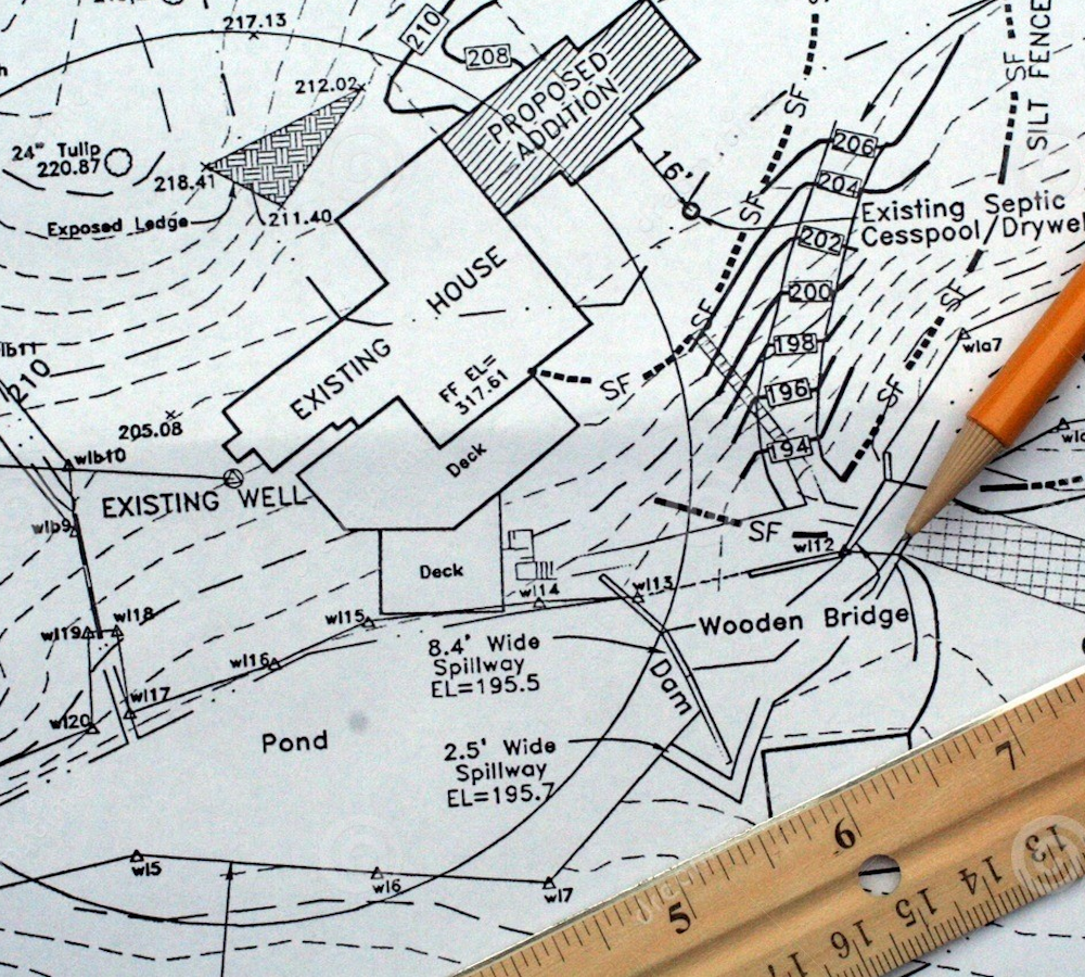
Land Development Planning
Site Planning, Boundary Line Adjustments, Short Platting, Platting, Feasibility, Consulting, Design Support Services


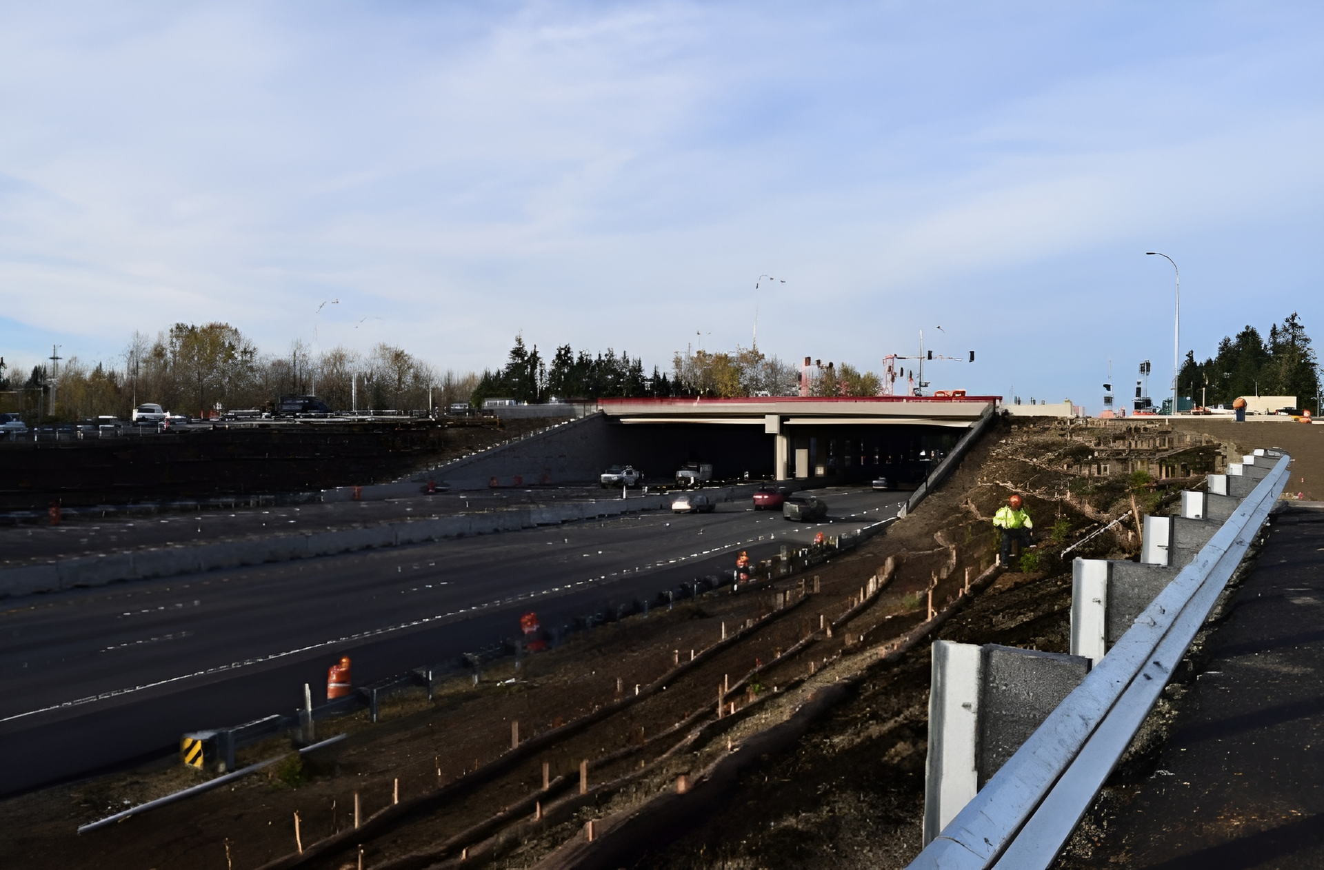
Construction Site Surveying That Builds Dreams
Building begins with a strong foundation, and our construction site surveying services ensure every project starts off right. We partner with federal, state, and local governments, offering precise construction staking and 3D modeling to navigate complex sites with confidence. Our seasoned surveyors provide reliable data to help you manage risks and timelines effectively, making us the preferred choice in the region. Lay the groundwork for success with us—contact us now for a quote!
Why We Stand Out: Our Strengths Unveiled
Founded on Experience
Unmatched local expertise.
Personalized Service
Client-centric service.
Precise & Professional
Proven project success record.
Innovative Land Development Planning Solutions
At the heart of every successful development is comprehensive land planning. Our expert team works closely with you to turn visions into viable plans, offering strategic insights backed by innovative technology. Whether it's a boundary survey or topographic data, we specialize in translating complex information into meaningful decisions that maximize potential. Partner with us to unlock your land’s Full potential and bring your concepts to life!
Hear From Our Satisfied Clients
Urban Land Use Planning:
Shaping Vibrant Societies
Our urban land use planning experts embody the spirit of sustainable growth, crafting harmonious balance within bustling communities. We provide insightful analysis and creative strategies to enhance urban landscapes while preserving essential elements. Our goal is to foster development that benefits both the environment and its inhabitants. Join us in designing future-ready spaces that enhance quality of life across the Pacific Northwest.
What Makes NorthLine Surveying so Popular?
When it comes to accurate and reliable surveying services in Port Townsend, we are proud to have a team of skilled professional land surveyors ready to assist you. Our professional land surveyors use the latest technology and equipment to deliver precise results for a wide range of projects, from boundary surveys to construction staking. We understand the unique challenges that each project presents, which is why our professional land surveyors approach every task with a commitment to excellence and innovation. With extensive experience working alongside federal, state, and private clients, our professional land surveyors ensure that each project is completed efficiently and effectively. Trust our expertise to bring clarity and accuracy to your next venture. You can also find professional land surveyors in the area.
Frequently Asked Questions
What land surveying services do you offer?
At NorthLine Surveying, we offer a broad range of services including boundary surveys, construction staking, topographic surveys, 3D modeling, and aerial mapping. Our expertise in construction site surveying and land development planning helps ensure your project is on solid ground from the start. We serve a wide variety of clients, including federal and local governments, contractors, and private individuals. Our experienced team uses the latest technology to provide accurate and efficient results. Curious about what we can do for your project? Contact us to discuss your specific needs and get a free consultation!
How does NorthLine Surveying ensure accurate results?
Accuracy is at the heart of what we do at NorthLine Surveying. We employ a team of licensed professional land surveyors and experienced technicians who use the latest tools and technology, including robotic total stations, GPS, and drones. This ensures precise measurements and reliable data for every task, from simple boundary surveys to complex construction site surveying. We take pride in our meticulous approach to every project, ensuring that we deliver results you can trust. Want to see how our expertise can benefit your project? Call us today for more information or to schedule a consultation!
In which locations do you offer land surveying services?
NorthLine Surveying’s main office is located in Burlington, WA in Skagit County. Our team of field surveyors are strategically located throughout the Pacific NW and are able to provide local expertise and knowledge to every job, no matter where it is located. We provide extensive experience and knowledge servicing the following counties and areas.
- Whatcom County
- Skagit County
- Island County
- San Juan County
- Snohomish County
- Chelan County
- King County
- Kittitas County
- Pierce County
- Lewis County
- Skamania County
- Clark County
- Cowlitz County
- Thurston County
- Mason County
- Kitsap County
- Grays Harbor County
- Jefferson County
- Clallam County
What makes NorthLine Surveying different from other surveying companies?
What sets NorthLine Surveying apart is our unwavering commitment to excellence and client satisfaction. With over 100 years of combined experience, our team brings a wealth of knowledge and expertise to every project. We use innovative solutions and advanced technology to provide accurate and efficient land surveying services. Additionally, our client-focused approach ensures that we are not just meeting, but exceeding expectations. Whether it's construction surveying or land use planning, we approach each project with a "whatever it takes" mentality. Ready to experience the NorthLine difference? Contact us today for a quote or consultation!
Get in Touch
KEEP IN TOUCH
Professional Land Surveyors
We are a team of professionals and high performers passionately committed to providing the highest level of service to our clients. Nothline Surveying Inc. is a place where mastery is always in the mission.
Our highly skilled and experienced staff of professionals are committed to our projects, our clients, and the relationships we have with them.
Contact Info
Phone:
Address:
1580 Port Drive, Burlington, WA 98233